Vegetation Archive of Subtropical and Tropical regions in China (VAST-China)
VAST-China is the database composed of many plot (relevé) data on every type of vegetation in China’s subtropical and tropical regions (23°~33°N, 98°~123°E). Until December 2021, VAST-China includes over 10,000 temporary/permanent sampling plots. For each plot, the information were gathered on both the vegetation composition and physical environment. These data were collected by over 1000 different sources, including personal collections by ourselves and other researchers of East China Normal University, and published books, monographs or journal articles. More details can be found here: http://www.givd.info/ID/AS-CN-006. If you are interested to use the data, please contact with me by email.
BEST (Biodiversity along Elevational gradients - Shifts and Transitions)
BEST is a long-term coordinated network for multi-taxon biodiversity monitoring in the Anthropocene. Currently, we have established over 200 permanant plots in 12 mountains in China. If you are interested to know more about the ongoing data collection, please visit our website https://best-mountains.org/, or contact with me by email.
An unmanned aerial vehicle visible light remote sensing image dataset of four forest dynamic plots in subtropical China
The evergreen broad-leaved forest is a zonal vegetation type in the subtropical regions of China. However, due to complex vertical structure and relatively dense canopy of subtropical forests, we are lack of reliable data in current canopy studies of this forest.
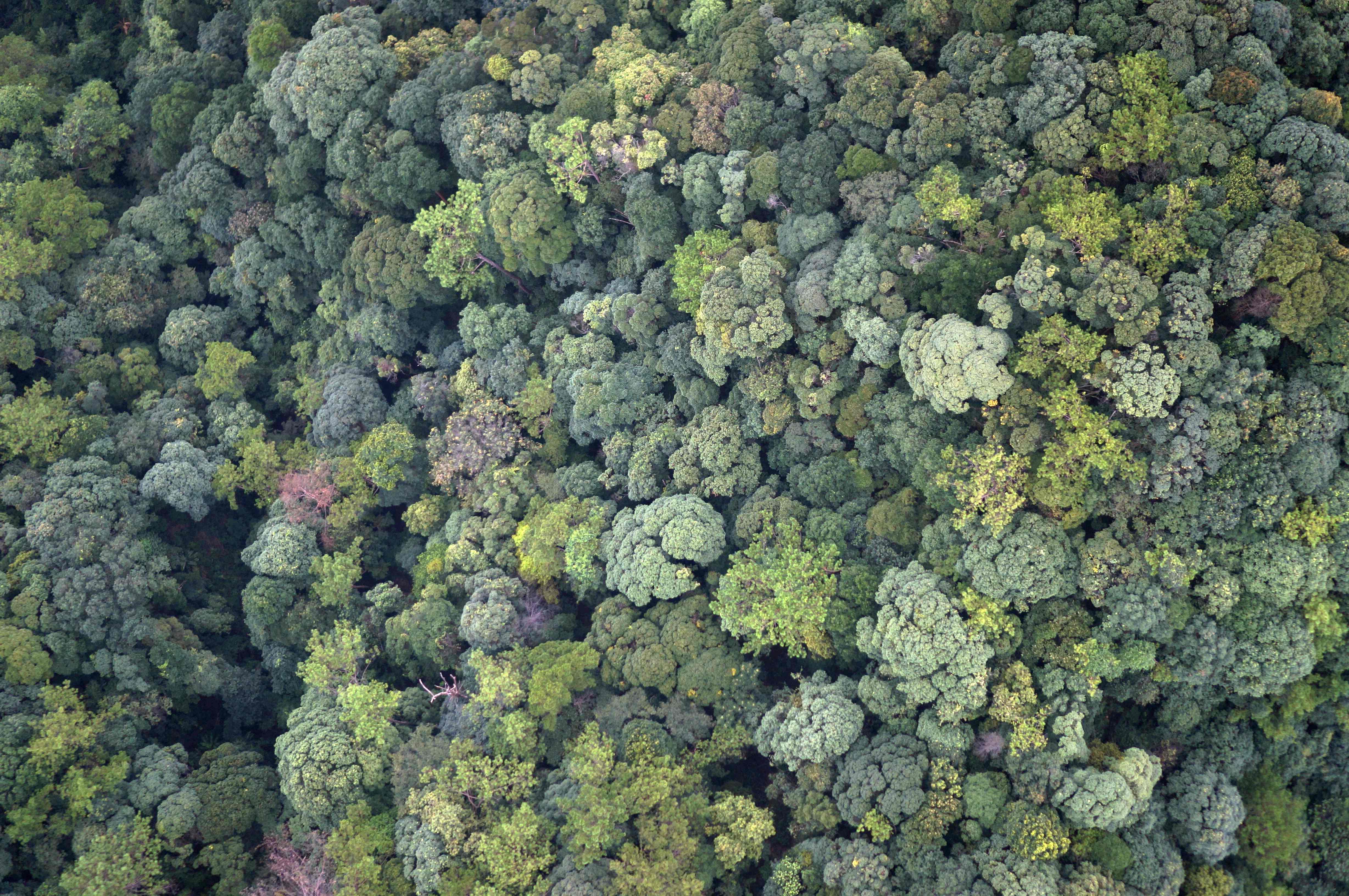
Here we present a large dataset of visible light remote sensing images of four large-scale (> 20 ha) forest dynamic plots in Tiantongshan and Baishanzu of Zhejiang, and Dinghushan and Chebaling of Guangdong. These data were collected by unmanned aerial vehicle (UAV) equipped with visible light camera in August of 2014 or September of 2016.
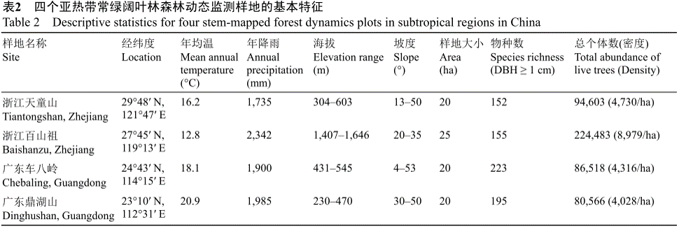
By combining the UAV data with ground survey data, we generated four data files for each plot: orthoimages and surface digital models with spatial resolution of ~5 cm, forest canopy height data with spatial resolution of 1 m, and data quality reports of the orthoimages. This dataset of evergreen broad-leaved forest provides significant supports for the studies in forest canopy ecology, biodiversity and ecosystem function.
Please cite this paper if you use the data:
Zhang, Z., Hu, J., Yang, Q., Lian, J., Li, B., Wang, X., Ye, W., Zhang, J.* 2021. An unmanned aerial vehicle visible light remote sensing image dataset of four forest dynamic plots in subtropical China. 中国亚热带4个森林动态监测样地无人机可见光遥感影像数据集. Biodiversity Science 生物多样性, 29(9):1181-1185. (In Chinese) doi: 10.17520/biods.2021299
Other related publications:
Zhang, J., Zhang, Z., Lutz, J., **, He, F. 2022. Drone-acquired data reveal the importance of forest canopy structure in predicting tree diversity. Forest Ecology and Management, in press.
Zhang, J., Huang, X., Zhou, Y., Ma, K. 2021. Biodiversity data papers: Standardizing and diversifying data sharing. 生物多样性数据论文: 规范化和多样化. Biodiversity Science 生物多样性, 29(9):1147-1148. (In Chinese) doi: 10.17520/biods.2021369
Biodiversity dataset of vascular plants and birds in Chinese urban greenspace
Urban greenspace plays an important role in buffering the threat of urbanization to biodiversity. Biodiversity research in urban greenspace is essential for understanding the impacts of human activities on biodiversity and the associated ecosystem functioning and services in urban ecosystems.
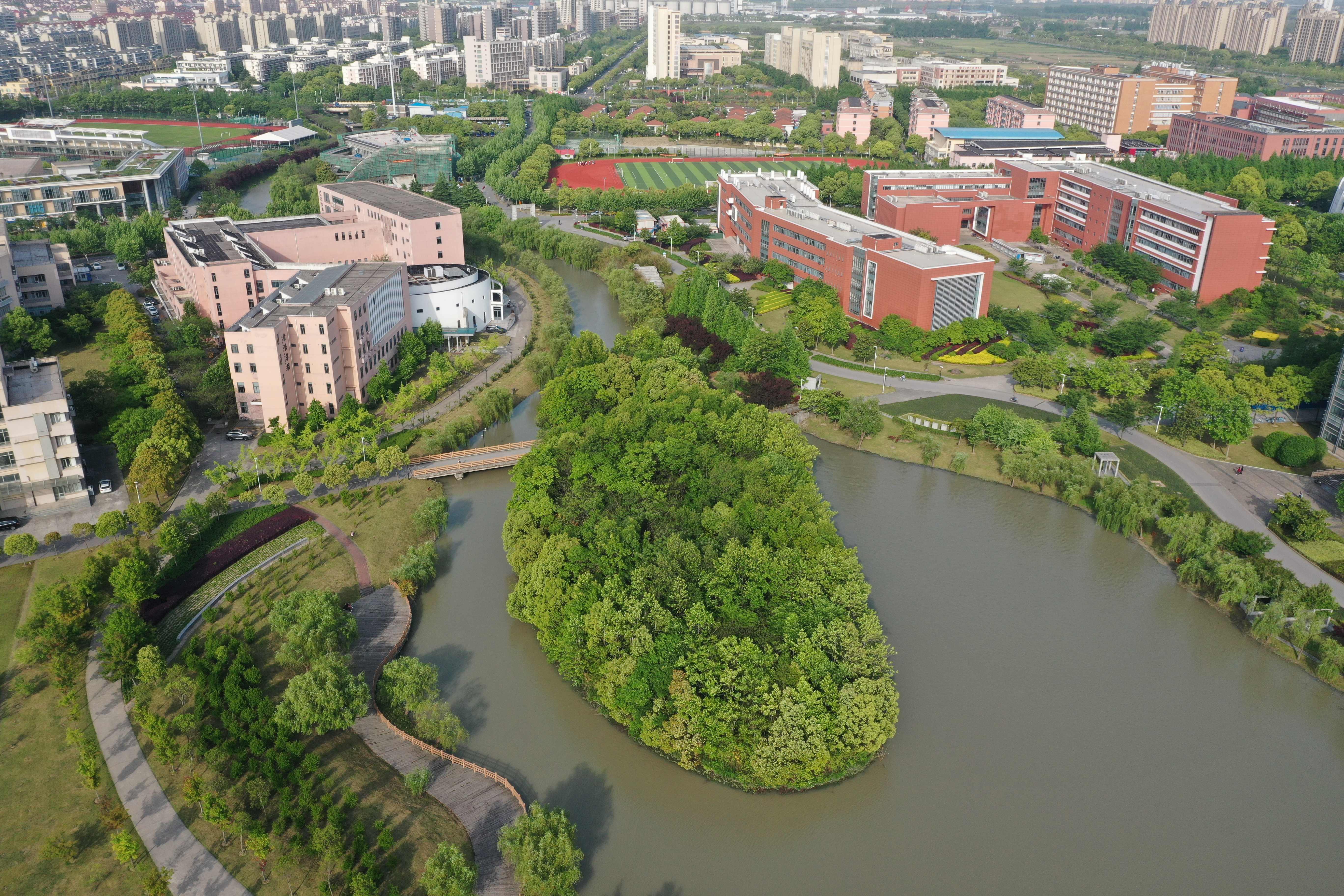
Here we provided a comprehensive biodiversity dataset of vascular plant and bird species in 286 university campuses and 118 urban parks in 143 cities in China, covering a wide range with different levels of urbanization (20–50°N in latitude and 81–130°E in longitude). Plant species were classified into different growth forms, and bird species were identified as resident or migrant.
In total, the dataset contains 46,558 occurrence records for 5,915 plant species (about 18% of all Chinese vascular plant species) and 6,423 records for 546 bird species (around 40% of all recorded bird species in China). This dataset provides an important data source for evaluating the anthropogenic effects of biodiversity changes and advancing urban ecology. The complete data set for this abstract published in the Data Paper section of the journal is available in electronic format in MetaCat in JaLTER at http://db.cger.nies.go.jp/JaLTER/metacat/metacat/ERDP-2021-02.1/jalter-en
Please cite this paper if you use the data:
Wang, X., Liu, J., Liang, C., Zhao, Z., Feng, G., & Zhang, J. (2021). Biodiversity dataset of vascular plants and birds in Chinese urban greenspace. Ecological Research, 36(4): 755-761. https://doi.org/10.1111/1440-1703.12240
Other related publications:
Wang, X., Svenning, J. C., Liu, J., Zhao, Z., Zhang, Z., Feng, G., Zhao, Z. & Zhang, J. (2021). Regional effects of plant diversity and biotic homogenization in urban greenspace–The case of university campuses across China. Urban Forestry & Urban Greening, 62, 127170.https://doi.org/10.1016/j.ufug.2021.127170
Liu, J., Zhao, Y., Si, X., Feng, G., Slik, F., & Zhang, J. (2021). University campuses as valuable resources for urban biodiversity research and conservation. Urban Forestry & Urban Greening, 64, 127255.https://doi.org/10.1016/j.ufug.2021.127255